Fast Eddie B
Well-Known Member
Karen and I just picked up our Clarity yesterday afternoon and I’ve only driven it about 80 miles home from the dealer. On that drive, I drove in EV mode until the EV range showed 5 miles, about 2/3 of the way home, then switched to HV mode.
I’d like to solicit some opinions on the best way to handle one of our common missions - driving between our two homes in N GA and Lenoir City, TN, about 95 miles driving and shown by the two blue dots here:
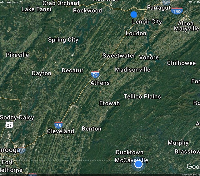
The dark green is the foothills of the Appalachians. There’s about a 900’ elevation loss overall from N GA to Lenoir City (from 1,800’ to 900’), and of course the same gain going the other way.
We have kind of alternated between two routes, depending on time of day, weather and inclination:
1) Pretty much heading straight north to Tellico Plains, then angling over towards Sweetwater and joining I-75, or,
2) Heading west along the Ocoee River towards Benton, then north to Athens and joining I-75 there.
The former has lots of twisties (making it a great motorcycling road!) and lots of altitude gains and losses. The latter along the river has much less altitude gain and loss and less twisties, but is marginally farther.
Questions:
1) Would one route be significantly more efficient for a PHEV? I’m thinking the latter’s longer distance would be more than compensated for by more level terrain overall. I realize we'll get some regenerate gains on the long downhills to make up for the uphills, but I think physics dictates you never get it all back.
2) How would you handle “modes” along either or both of these routes? Start out in EV to a certain battery level and then switch to HV, or maybe just make the whole drive in HV and be done with it. I think our goal is to arrive at our destination with as little charge as practicable to get maximum benefit from charging.
I’m sure this will all become clear in short order, but curious as to what sort of routines others in a similar situation may have settled upon.
Thanks in advance!
I’d like to solicit some opinions on the best way to handle one of our common missions - driving between our two homes in N GA and Lenoir City, TN, about 95 miles driving and shown by the two blue dots here:
The dark green is the foothills of the Appalachians. There’s about a 900’ elevation loss overall from N GA to Lenoir City (from 1,800’ to 900’), and of course the same gain going the other way.
We have kind of alternated between two routes, depending on time of day, weather and inclination:
1) Pretty much heading straight north to Tellico Plains, then angling over towards Sweetwater and joining I-75, or,
2) Heading west along the Ocoee River towards Benton, then north to Athens and joining I-75 there.
The former has lots of twisties (making it a great motorcycling road!) and lots of altitude gains and losses. The latter along the river has much less altitude gain and loss and less twisties, but is marginally farther.
Questions:
1) Would one route be significantly more efficient for a PHEV? I’m thinking the latter’s longer distance would be more than compensated for by more level terrain overall. I realize we'll get some regenerate gains on the long downhills to make up for the uphills, but I think physics dictates you never get it all back.
2) How would you handle “modes” along either or both of these routes? Start out in EV to a certain battery level and then switch to HV, or maybe just make the whole drive in HV and be done with it. I think our goal is to arrive at our destination with as little charge as practicable to get maximum benefit from charging.
I’m sure this will all become clear in short order, but curious as to what sort of routines others in a similar situation may have settled upon.
Thanks in advance!
") For either route, I’d suggest starting with an almost fully charged battery (<80%) and using HV mode the entire trip. Post back on which works better for your Clarity’s performance!
For either route, I’d suggest starting with an almost fully charged battery (<80%) and using HV mode the entire trip. Post back on which works better for your Clarity’s performance!